River-Styles-Workshop
River Styles Workshop Website
Workshop Topics > Day 2 >
H. Mapping & Naming River Styles
Background
Synopsis of Topic
To actually map and classify the drainage network, you will need to have defined your river types (River Styles), and then you will need to choose their boundaries on the drainage network. In this exercise you will:
- Define your own River Styles Tree
- Apply that classification to your drainage network and delineate reach boundaries
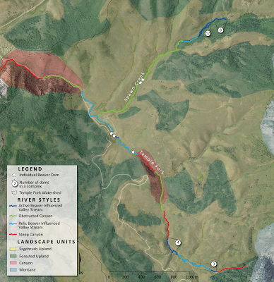
Temple Fork Example of River Styles
Figure from Lokteff et al. (2013) produced by Martha Jensen.
Why We’re Covering It
This is the exercise in which you will gain experience in actually classifying your drainage network using River Styles that you develop (i.e. Stage 1).
Learning Outcomes
This topics helps us with the following learning outcomes for the workshop:
- Through lectures, laboratory exercises, field visits and discussions, develop a working knowledge of Stage 1 of the River Styles framework (river character and behaviour, analysis of catchment-scale river patterns)
Resources
Mapping Layers for Logan River:
-
LoganRiverMainstemNHD.kmz - The NHD drainage network of just the mainstem of the Logan River (the one one you need for today’s excercise)
-
LoganRiver.zip - Shapefiles of the NHD Drainage Networks for editing in ArcGIS
-
LoganRiverWatershedNHD.kmz - The NHD drainage network for the Logan River Watershed
-
BlacksmithForkNHD.kmz - The NHD drainage network for the Blacksmith Fork Watershed
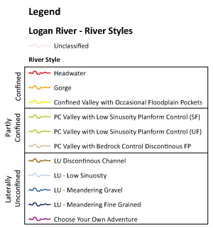
Symbology to use:
LoganRiver_RiverStyles.lyr - Import this symbology definition into your LoganRiverMainstem_NHD shapefile.

Relevant or Cited Literature
-
Brierley, G. and Fryirs, K. 2005. Geomorphology and River Management: Applications of the River Styles Framework. - Blackwell Publishing.
-
- See p 261-287 (§9.3) of Chapter 9 of Brierley & Fryirs (2005) for Stage One, Step Two
- See Chapter 4 of Brierley & Fryirs (2005) for overview of ‘River Character’
- See Chapter 5 of Brierley & Fryirs (2005) for overview of ‘River Behavior’

