gis
Taking time to carefully plan your figure layout is an important first step and can save you from tediously re-sizing or even re-making all your figure components. Key things to consider:
-
size of the final figure (e.g. full page: 8” x 10”, half page: 8” x 5”)
-
number of individual maps
-
shape of individual maps (e.g. square or rectangle)
-
- Rule of Thumb: same size square maps will be easier to layout together in a figure than different size rectangular maps
-
size of the legend
-
size of any additional graphs or tables
- Rule of Thumb for Manuscript Figures: your figure will most likely be reduced when published so make sure text is still legible when shrunk to half of it’s current size
EXAMPLE LAYOUT:
Consider a scenario where we need to produce a figure that is comprised of 6 different maps where the scale of each map will be different (so each map will need its own scale bar), but we can use single legend. We could layout the figure in Arc using the Layout view or in the vector graphics program that we will ultimately use to construct the figure (e.g. Adobe Illustrator). An example of a well thought out layout for this scenario is:
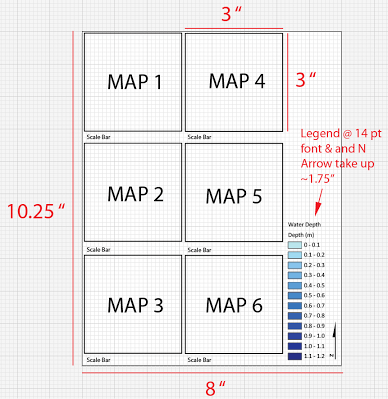
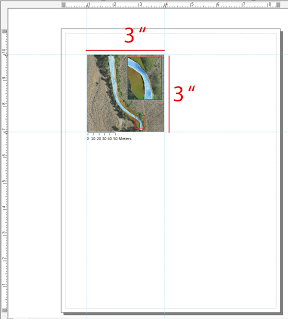
By carefully laying out the figure we determined that each of the individual maps needs to be 3” x 3”. Now in Arc we can actually set the layout view map frame to exactly 3” x 3” which will make exporting the maps from Arc and building the figure much easier:
← Back to 1. Recognizing What’s Wrong With Typical GIS Maps
Next to → 3. Use ArcGIS ONLY for Making Figure Building Block