joewheaton.org
Joe's personal web pages
Home > Research > Projects
Big River Protocol Development
Introduction & Statement of Problem
The Northern Colorado Plateau Network (NCPN) is working on developing a big river protocol for monitoring that will be implemented at Dinosaur National Monument (DINO), Canyonlands National Park (CANY), Black Canyon of the Gunnison National Park (BLCA), and Curecanti National Recreation Area (CURE). These four parks contain portions of the Colorado, Green, Gunnison, and Yampa rivers, four of the principle rivers comprising the upper Colorado River drainage. Due to their extraregional size and complexity, developing a big river monitoring protocol is NCPN’s highest priority. One of the largest challenges involves monitoring and detecting change along large rivers in remote, canyon-bound settings typical of the Colorado Plateau.
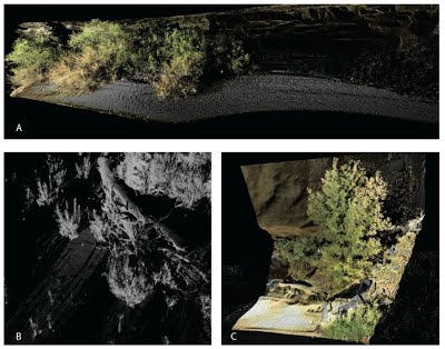
The emergence of ground-based Light Detection and Ranging (LiDaR; a.k.a. terrestrial laser scanning – TLS) has made it possible to capture the actual three-dimensional structure of complex natural habitats (Brasington et al., 2008; Hodge et al., 2009, see also Figure 1). The rapid acquisition, high resolution, and exceptional (+/- 5 to 10 mm) accuracy of the raw data make it very well suited to change detection problems such as repeat monitoring of riparian corridors of big rivers. NCPN is interested in testing the applicability of ground-based LiDAR or terrestrial laser scanning (TLS). The TLS scans also include the potential to differentiate between major types of vegetation that could potentially replace some of the data collected by traditional vegetation plot sampling and extend the spatial coverage of such sampling. However, the equipment is heavy and expensive and workflows using the technology in remote, canyon-bound, rivers needs testing and comparison with traditional methods. The USU Ecogeomorphology and Topographic Analysis Lab proposes to conduct TLS surveys and work on algorithm development of TLS analysis tools, which could be operationalized in a larger-scale big river monitoring protocol.
Figure 1 – Assorted Views of Raw 3D Point Clouds from individual Terrestrial Laser Scan Surveys by PI. A) View of a eddie bar deposit colonized by vegetation showing ability of TLS to capture both geomorphology (topography) and 3D structure of vegetation simultaneously (shown in true-color). B) Close-up of young-willows and large woody debris; data is analogous to detail necessary to capture beaver dams (gray-scale). C) Close up of a Box Edler Tree and other riparian vegetation against canyon wall (true color). Note, these are NOT photographs, but raw individual point data.
Research Objectives
The objectives of this project have been clearly defined by the U.S. Geological Survey as assessing the effectiveness of ground-based LiDAR in detecting vegetation and geomorphic change for use in riparian monitoring along large rivers of the Colorado Plateau. The specific objectives are to:
- Collect, process, and analyze ground-based LiDAR data at two locations within Dinosaur National Monument, in conjunction with traditional transect- and plotbased data used to detect channel cross-section and vegetation change.
- Process and analyze LiDAR data to evaluate its utility in monitoring geomorphic and vegetative change in big rivers.
- Use Ground-based LiDAR data to evaluate the accuracy of existing airborne LiDAR data and accuracy of traditional vegetation transects.
- Produce peer-reviewed publication(s) comparing and contrasting ground-based LiDAR monitoring with traditional monitoring methods, in conjunction with USGS and National Park Service collaborators.
This work could have implications for how NCPN and others throughout theworld involved in monitoring dynamics and change in rivers go about conducting monitoring. It may also reveal interesting new patterns of change previously unidentifiable because they were not measureable. The proposed research is therefore both of practical relevance to resource managers and scientific relevance to the broader research community.
Current Study Sites:
Green & Yampa Rivers of Dinosaur National Park
Collaborators:
Dr. Michael Scott (USGS) Dusty Perkins (National Park Service) Rebecca Manners (Utah State University) Jack Scmidtt (Utah State University)
Outputs of this Research:
- Manners RB, Schmidt J and Wheaton JM. In Revision. Multi-scalar model for the determination of spatially explicit riparian vegetation roughness. Journal of Geophysical Research - Earth Surface.
- Scott ML, Perkins DL and Wheaton J. 2012. Final Report: Big River Protocol Development – A Prototype Warranty Project, USGS, Fort Colins, CO, 198 pp.
NPS2010-ClimateChangeProposalUSU.kmz (6k) Joseph Wheaton Jan 20, 2010, 6:34 PM


