NSF - Sensitivity of Braided River Morphodynamics to Sediment Supply

Project Type: Sponsored Research Project Sponsor: National Science Foundation: Geomorphology and Landuse Dynamics Project Location: River Feshie, Scotland & River Rees, New Zealand Status: Completed, April 2016
Project Overview
Purpose of Project:
This project seeks to better predict the response of braided rivers to changes in flooding regimes and sediment supply by combining unprecedented high resolution monitoring data from braided rivers with a new simulation model that will allow predictive experimentation.

Abstract:
This project seeks to predict how gravel braided rivers will respond to changes in sediment supply, which may be expected as a result of climate change. It seeks to better predict the response of braided rivers to changes in flooding regimes and sediment supply by combining unprecedented high-resolution data from braided rivers in Scotland and New Zealand with a new simulation model that will allow predictive experimentation over tens to hundreds of years. The project addresses a deficiency in current predictive river modeling capability by developing a model many researchers have called for over the past two decades. We have a pilot version of this model working and we will extend, refine, and rigorously test this model before making it available to the broader research and river management communities. The insight gained from our planned experiments, as well as our plan to make the new modeling tool available, may open up new avenues of experimentation and discovery.
Braided rivers are those in which the flow is divided into multiple parallel channels that split and come back together around large bars (sediment deposits) repeatedly like the intertwined strands of a rope. Braided rivers represent some of the most energetic and rapidly evolving environments and are frequently hotspots for biodiversity and serve as vital habitat for salmon as well as other highly valued species. Braided rivers were historically much more common, but engineering and river management have worked to discourage braiding. Increasingly, efforts to restore rivers are recognizing the importance of sometimes promoting braiding. It is likely that climate-change-induced shifts in flooding and the amount of sediment (e.g., gravel and sand) supplied from upstream could push many rivers back to a braided state. Despite the importance of braided rivers, our ability to predict their behavior and understand their function is immature at best. This project aims to advance both. Aside from the scientific value of the research, the project can help provide guidance to river managers and restoration practitioners charged with working with and/or restoring braided rivers. These professionals are seek reasonable quantitative predictions for managing braided rivers. The project broadens the participation of underrepresented groups through initiatives involving research opportunities for undergraduates and new experiences for K-12 students. The project leverages a variety of existing resources (e.g., field data, computational resources, outreach programs, web portals) by pursuing collaborations with funded efforts of other organizations, some supported by NSF. Finally, the modeling approaches developed as part of this research could help advance simulation modeling efforts in other fields interested in forecasting climate change impacts and/or environmental management.
Related Links & Research
- Alan Kasprak began this work with funding and support from a DOE/ICRRR: MoRPHED PhD Studentship, and then was funded with this NSF grant, and finishing up funds from USU
- MoRPHED
Project Outputs
Papers from this Project
- \2015. Kasprak* A, Wheaton JM, Ashmore PE, Hensleigh JH, & Peirce S. The Relationship Between Particle Travel Distance and Channel Morphology: Results from Physical Models of Braided Rivers. JGR Earth Surface. DOI: 10.1002/2014JF003310.
-
- Wheaton JM, Brasington J, Darby SE, Sear DA, Vericat D‡., and Kasprak A*. 2013. Morphodynamic signatures of braiding mechanisms as expressed through change in sediment storage in a gravel-bed river. Journal of Geophysical Research - Earth Surface. DOI: 10.1002/jgrf.20060.
- Accepted. Vericat D, Wheaton JM and Brasington JA. Revisiting the morphological approach: opportunities and challenges with repeat high resolution topography. Invited submission for edited volume for Gravel Bed Rivers 8.
In Preparation
- In Prep. Kasprak A*, Wheaton JM, Brasington J, and Hafen K‡ . Coming to grips with model imperfection: morphodynamic models as exploratory tools for understanding braided river dynamics. For submission to: Journal of Geophysical Research: Earth Surface or ESPL. DOI: 10.6084/m9.figshare.1598208
- In Prep. Kasrpak A*, Wheaton JM, Brasington J, and Hafen K. The sensitivity of braided river morphodynamics to variations in sediment source. For submission to: Geology. DOI: 10.6084/m9.figshare.1598216.
Dissertation from this Project
- Kasprak, Alan, “Linking Form and Process in Braided Rivers Using Physical and Numerical Models” (2015). All Graduate Theses and Dissertations. Paper 4513. http://digitalcommons.usu.edu/etd/4513
Presentations from this Project
- Poster: Kasprak A, Brasington J, Hafen K, Wheaton JM. 2015. An efficient and imperfect model for gravel-bed braided river morphodynamics: numerical simulations as exploratory tools. EOS, Transactions, American Geophysical Union. San Francisco, CA - December 14-18, 2015. DOI: 10.6084/m9.figshare.2063289.v1
- Talk: Kasprak A, Hafen K, Wheaton JM. 2015. A simplified morphodynamic model for gravelbed rivers. 10th Federal Interagency Sedimentation Conference. Reno, NV - April 19-23, 2015. Awarded Best Student Technical Paper.
- Poster: Kasprak A, Wheaton JM, Ashmore P, Peirce S. 2013. The sensitivity of sediment pathlengths to channel morphology: results from physical models of braided rivers. Braided Rivers Workshop. Die, France - June 23-27, 2014.
- Talk: Kasprak A, Wheaton JM, Ashmore P, Peirce SA (2013). The Relationship Between Particle Travel Distance and Channel Morphology: Results from Physical Models of Braided Rivers.. Fall Meeting, American Geophysical Union. San Francisco, CA.
- Poster: Kasprak A and Wheaton JM. 2012. Towards a Simplified, Step-Length-Based Morphodynamic Model for Gravel Bed River Evolution. National Center for Earth Surface Dynamics - Summer Institute for Earth Surface Dynamics, Minneapolis, MN.
- Poster: Kasprak A and Wheaton JM. 2012. Towards a Simplified, Step-Length-Based Morphodynamic Model for Gravel Bed River Evolution. USU Spring Runoff Conference, Logan UT.
- Poster: Kasprak A and Wheaton JM. 2011. Modeling Gravel-Bed-River Morphodynamics Using a Step-Length-Based Approach. Community Surface Dynamics Modeling System Annual Meeting, Boulder, CO.
- Poster: Kasprak A and Wheaton J. 2011. Morphodynamic Modeling of Gravel Bed Rivers: a Step-Length Based Approach, AGU Fall Meeting 2011. American Geophysical Union: San Francisco, CA. EP23C-0778.
Software or Tools from this Project
Datasets from this Project
- OpenTopography
- CSDMS
Relevant Figures from this Project
A variety of step-length distributions can be used to parameterize the model; we are investigating the transferability of these distributions between study sites to determine the degree to which various braided rivers share step-length-distributions.
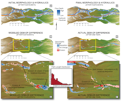
MoRPHED uses an input elevation surface (DEM), along with initial conditions describing water and sediment supply from upstream, along with an input step-length distributions. Hydraulics are computed using a CFD model which solves the Navier-Stokes Equations (in this case, in two dimensions). Flowlines are delineated, and sediment is mobilized downstream with a distance defined by the chosen step-length distribution. Bed elevation is computed using the Exner Equation for sediment continuity, and the process is repeated.The model timestep is equivalent to one mobilizing event.
Results of the morphodynamic model for the River Feshie (UK) study reach over four floods. Initial morphology and hydraulics are shown in (A), with post-flood results in (B). Model was run for a single grain size. DEMs-of-Difference (DoDs) obtained by differencing pre- and post-flood topography are shown for model (C) and for field-based surveys (D). Areas of detail for each DoD shown in (E) and (F). Note the correspondence between areas of deposition, but differences resulting from not including bank erosion in the model’s process representation.
Project Details
Project PI: Joseph Wheaton Project Personnel from ET-AL: Alan Kasprak (PhD Student) & Konrad Hafen (Underaduate) Project Collaborators: Collaorator Names and Links (comma separated list) Funding Source: National Science Foundation: Geomorphology and Landuse Dynamics(NSF Award: 1147942) Project Start Date: ** April, 2012 **Project End Date (anticipated): March, 2015


