gis
«««< Updated upstream
«««< Updated upstream
Stashed changes
title: Geoprocessing —
Introduction to Lab
Background
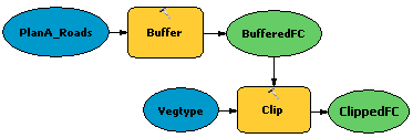
We’ve been using geopocessing all semester without calling it that. One of the ways to really unleash the power of geoprocessing is through building Models which allow you to automate GIS Tasks and combine multiple steps into one.
Data for Lab
Refer back to Lab 6, Task 3 & Lab 7, Task 1.

Lab Objectives
This lab is intended to teach you the basics of geoprocessing in ArcGIS using model builder. You will be required to build a model that pieces together a string of geoprocessing tasks you need to complete an analysis for your project.
Meets Course Learning Outcomes 2, 3 & 4.
Task 1
This lab consists of a single task in which you will build a model that combines multiple geoprocessing tasks or steps into one step. You can choose any problem you want. If you already know how to use model builder you can get right to it. If you’ve never used model builder, you may find some of these tutorials useful:
Geoprocessing Tutorials:
What to Submit
Prepare a webpage for this lab on your personal website for the course and prepare the following within that page or subpages (child pages):
-
A written overview of the model you built:
-
- What your model does,
- why it was necessary,
- how you built it,
- what existing geoprocessing tools it combines.
- You should show a figure of your model and post the toolbox
*.tbxthat you make to your website.

- A map or series of maps showing the input(s) to your model and output(s).
Make sure your lab conforms to the general lab submission guidelines. Submit a URL for this lab’s webpage.
Additional Resources
«««< Updated upstream
======= — title: Geoprocessing —
Introduction to Lab
Background
We’ve been using geopocessing all semester without calling it that. One of the ways to really unleash the power of geoprocessing is through building Models which allow you to automate GIS Tasks and combine multiple steps into one.
Data for Lab
Refer back to Lab 6, Task 3 & Lab 7, Task 1.

Lab Objectives
This lab is intended to teach you the basics of geoprocessing in ArcGIS using model builder. You will be required to build a model that pieces together a string of geoprocessing tasks you need to complete an analysis for your project.
Meets Course Learning Outcomes 2, 3 & 4.
Task 1
This lab consists of a single task in which you will build a model that combines multiple geoprocessing tasks or steps into one step. You can choose any problem you want. If you already know how to use model builder you can get right to it. If you’ve never used model builder, you may find some of these tutorials useful:
Geoprocessing Tutorials:
What to Submit
Prepare a webpage for this lab on your personal website for the course and prepare the following within that page or subpages (child pages):
-
A written overview of the model you built:
-
- What your model does,
- why it was necessary,
- how you built it,
- what existing geoprocessing tools it combines.
- You should show a figure of your model and post the toolbox
*.tbxthat you make to your website.

- A map or series of maps showing the input(s) to your model and output(s).
Make sure your lab conforms to the general lab submission guidelines. Submit a URL for this lab’s webpage.
Additional Resources
Stashed changes Stashed changes See the Additional Resources for this Lecture Topic